‘Complete Streets’ Redesign for Hoboken’s Washington Street
In 2010, Hoboken adopted a Complete Streets policy to make streets throughout the mile-square city meet federal and state standards for multi-modal street design and traffic control, ensure compliance with the Americans with Disabilities Act (ADA) guidelines on public rights-of-way, and balance the needs of pedestrians, bicyclists, transit users, and motorists. At a public meeting Tuesday night in Hoboken, planners from RBA Group presented a concept plan and design details for the Complete Streets redesign of Washington Street, the primary social, civic, and cultural hub of Hoboken, and the core of city’s central business district.

At community input meetings in December, 2013, and May, 2014 the planners shared their assessment of Washington Street’s current conditions, and residents provided suggestions, ideas, and feedback on preliminary design options. Major issues identified at these meetings included: an outdated traffic signal system that doesn’t meet current visibility standards; lack of designated space for bicyclists which leads to bicycle-pedestrian conflict on sidewalks; inadequate provisions for commercial loading and unloading, which leads to illegal use of intersection clear zones and pedestrian crosswalks; poor nighttime visibility for pedestrians and motorists because of ineffective lighting, inadequate stormwater management which leads to street flooding; and a pedestrian experience in need of significant safety, convenience, and accessibility upgrades.
To address these issues, RBA presented a “Complete, Green, and Smart design concept for Washington Street that calls for:
- Streamlining pedestrian and vehicular traffic flow by replacing existing traffic signals with larger fixtures that meet current visibility standards, and include pedestrian countdown signal heads
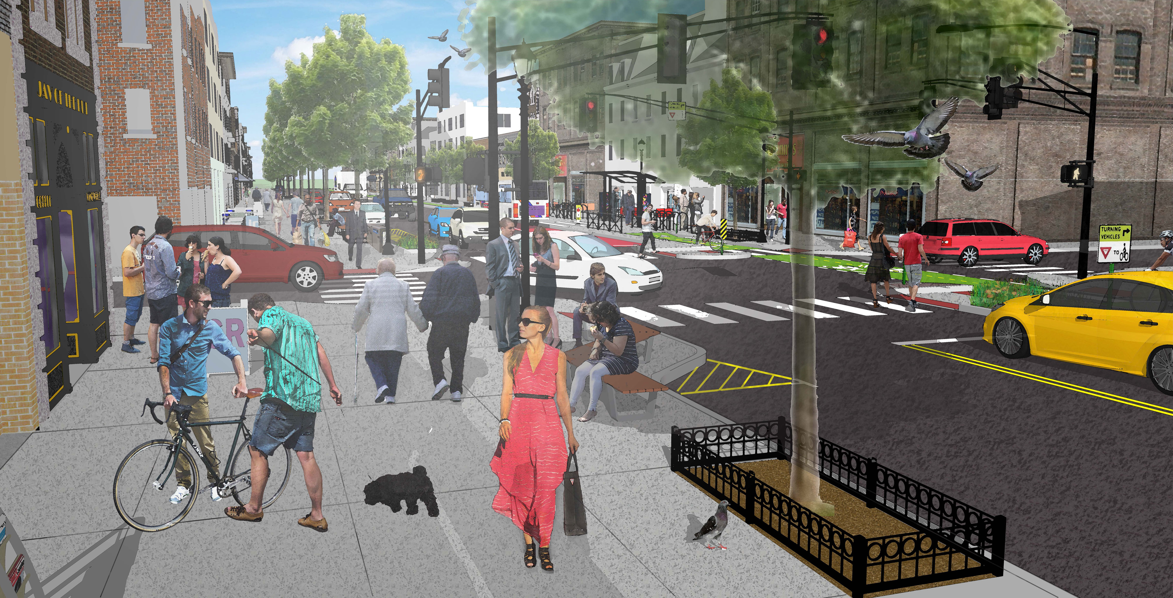
- Improving pedestrian crossing safety and accessibility by adding curb extensions that halve the crossing distance (56 feet downtown/64 feet uptown -> 26 feet at all intersections) and shift the turning radius for cars away from the edges of intersections
- Reducing conflict between pedestrians and bicyclists by adding a protected two-way bike lane below 8th street, and above 8th street a northbound protected bike lane and a southbound shared lane
- Maintaining existing parking, but moving it away from the sidewalk so that it functions as a buffer between vehicular traffic and a protected two-way bike lane
- Reducing the width of the travel lanes to deter double parking and the resulting traffic backups that start on Washington Street and cascade to cross streets
- Upgrading and replacing lighting, street furniture, bus shelters, bike parking facilities, and green infrastructure to improve the pedestrian experience, provide provide amenity space for informal social activity, and improve storm water management
- Adding 32 designated commercial loading and unloading zones to the 17-block street for deliveries to restaurants, bars, and retail stores between 6AM-2PM. After 2PM, the zones would provide 30-minute, on-street parking for 64 vehicles each day.

Traffic signals would be paired to change in sync, as opposed to the current conditions where all signals generally change at the same time. RBA found that buses travel at 6-8mph on average, and bikes travel at 8-10mph on average, so syncing signal-pairs and timing them to those speeds would improve traffic flow and reduce backups. Since New Jersey law requires turning traffic to be stopped if bicycle-specific signals are used, the traffic engineers from RBA felt that signal pairing and timing to keep buses and bicycles moving would have a smoothing effect on overall traffic flow.
RBA found that the current, hut-style bus shelters impede pedestrian flow on the surrounding sidewalks, and are not heavily used by transit riders, so the design recommends replacing them with portal-style shelters that have a smaller footprint, improve pedestrian flow, and encourage people to use transit. Although remnants of road surface markings are visible at some bus stops, consistent, high-visibility markings would help reduce instances of illegally parked cars blocking bus stops, so RBA recommended using colorized pavement to designate bus stopping areas. At bus stops where the protected, two-way bike line bisects the bus stopping area and shelter, the engineers recommended a grade change in the bike lane to signal that cyclists must yield to transit users, and additional buffer space to give bus riders adequate area to wait while boarding buses.

North of 8th Street, the current front-in angled parking would change to back-in angled parking, similar to the recent change along Willow Avenue between 11th-13th Streets. Back-in angled parking maintains capacity, but improves safety because departing cars drive forward and merge directly into the travel lane instead of backing into oncoming bike and vehicular traffic. One concern raised by an attendee was whether the exhaust from idling cars would pose a health risk. Gordon Meth, director of engineering at RBA, noted that New Jersey prohibits idling for more than three minutes, and enforcement would help ensure that drivers comply with the law when using back-in, angled parking spaces. South of 8th Street, the RBA engineers recommended striping the parallel parking spaces to improve visibility of open spaces, guide drivers into using only the space necessary for their vehicle, and enable the city to use technology to track whether each occupied space has been paid, which helps drive down enforcement costs.
The plan suggests retaining and refurbishing existing light poles, and replacing existing light fixtures with modern, arm-mounted, LED fixtures. Since PSE&G will cover upgrade costs to stay with the existing lighting style, RBA noted that replacing every other fixture with the modern arm-mounted lights could offer cost savings over replacing every fixture at once. Several attendees commented that they would prefer full replacement of all fixtures to the modern style even if the cost is higher.

In addition to pedestrian countdown signals at each crosswalk, the design also recommends replacing the existing brick paved crosswalks with high-visibility striped crosswalks to improve pedestrian visibility to drivers, especially in low-light situations and at night. Concrete curb extensions at each intersection would reduce the crossing distance from 56 feet downtown and 64 feet uptown to 26 feet. Gray, concrete sidewalks with soft cut joints in a grid pattern would provide a consistency not present in the current mix of styles and materials, and simplify sidewals repair or replacement. Along sidewalks, the design calls for modern street furniture, and and at curb extensions, benches installed in an angular arrangement would increase seating and encourage more informal social activity. The design also calls for increased bike parking, and RBA suggested creating a custom bike rack featuring the iconic “H” seen in the PATH station at Hoboken Terminal.

The proposed improvements are expected to cost $14 million and take about 12 months to complete, and the city plans to coordinate construction with utility upgrades already planned by PSE&G and United Water. The city will likely use a combination of funding from federal and state transportation programs, as well as a bond-issue, which will require a vote by the City Council, likely to take place after a presentation of the design at the October 15th meeting. Two elements are already moving forward: new wayfinding signage, and solar-powered Big Belly trash and recycling containers along Washington Street. Installation of the receptacles is already underway, and the city received a $919,373 grant from the New Jersey Economic Development Authority for wayfinding signs throughout the city.
This is a transformative plan for Washington Street and Hoboken, which would improve traffic flow, reduce bicycle-pedestrian-vehicle conflict, encourage people to use transit with upgraded bus shelters and stops, reduce street flooding by improving collection and dispersal of stormwater, and provide commercial loading and unloading space to reduce double parking. RBA noted that members of the National Association of City Transportation Officials (NACTO) reviewed the design concepts and provided guidance to team throughout the design development process. Nevertheless, there are people in Hoboken who are opposed to any change. A post on the City of Hoboken’s Facebook page announcing the public meeting was met with several comments strongly opposing any change to Washington Street, as has been the case throughout this public process.
(function(d, s, id) { var js, fjs = d.getElementsByTagName(s)[0]; if (d.getElementById(id)) return; js = d.createElement(s); js.id = id; js.src = “//connect.facebook.net/en_US/all.js#xfbml=1”; fjs.parentNode.insertBefore(js, fjs); }(document, ‘script’, ‘facebook-jssdk’));
As it currently stands, Washington Street is a civic and commercial success not because of its design, but in spite of it. Washington street is too important to the city’s economic, social, and civic health to continue to prioritize the needs of drivers over all other users of the street, and the idea that reducing or reconfiguring parking would hurt businesses is an urban legend. A 2008 NYCDOT redesign of 9th Avenue between 23rd-31st Streets that has many similar elements to the proposal for Washington Street resulted in a 49% increase in retail sales over the three years following the redesign, significantly outpacing the 26% average growth over the same three-year period elsewhere in NYC. This project is essential to the economic, social, and cultural vitality of Washington Street, and will help Hoboken continue to be a leading destination in the NYC metro area for residents, businesses, and visitors.